Posts

Showing posts from June, 2022

Arkansas Adventure

Image
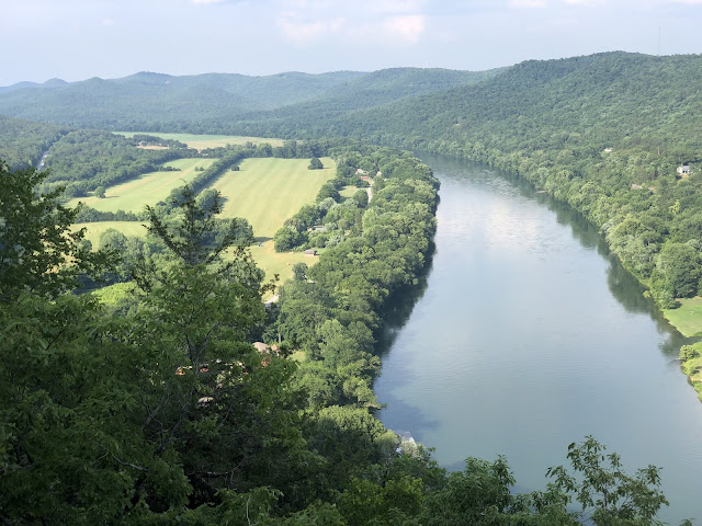
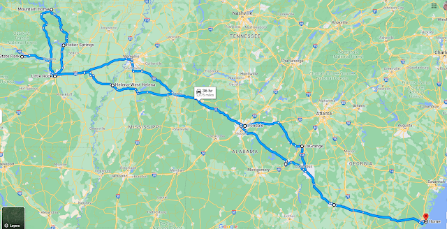
Great, early summer driving trip to Arkansas, with stops in Georgia, Alabama, and Mississippi along the way.  The weather was sunny and hot, so we spent a lot of time kayaking on cold water rivers, the Little Red and the White.  2000+ miles driven, 35 river miles kayaking, 50 miles biking, and another 20 miles or so hiking.  There's so much to do we'll definitely need several more trips to enjoy all the variety Arkansas has to offer. View of Bull Shoals Dam which was generating 245MW of electricity and sending us down river at 5-6 miles per hour!  Water was 55 degrees F.

Chattahoochee River Trail

Image
Bike trail in Columbus, GA, along the banks of the Chattahoochee River.  Nice rapids in downtown Columbus!  We'll have to come back for a rafting trip.

Delta Heritage Trail

Image
Long bike ride on the trail from Lexa to Lakeview and back. Near Helena, AR, in the Mississippi Delta region.  Old Town Lake in Lakeview. 

Petit Jean State Park

Image
View of Arkansas River valley from Stout's Point. Near Pontoon, AR.  Turtle Rocks. Rock House Cave,

Mt Nebo State Park

Image
Oauchita Mountains park with hiking and mountain bike trails. Near Dardanelle, AR. View of Mount Magazine (2753') to the west. 

White River

Image
18 mile kayak trip from Bull Shoals Dam to Cotter Springs.  Water, water and more water!  Near Mountain Home, AR. 

White River Bluff Trail

Image
Ozark National Forest. Near Mountain View, AR.

Little Red River Re-Run

Image
This time from Barnett access (Swinging Bridge) to Lobo access. River still running high and cold!  Near Heber Springs, AR. 

Arkansas River Trail

Image
16 mile bike loop around Little Rock and North Little Rock, AR. View looking west from Big Dam Bridge. Pinnacle Mountain is prominent in the distance, with I-430 bridge in the foreground.

Pinnacle Mountain

Image
Short hike via West Summit trail at State Park. Lake Maumelle and Ouachita Mountains view. Near Little Rock, AR.

Sugarloaf Mountain

Image
Short hike to summit attempt. Near Heber Springs, AR. Little Red River in the distance. 

Little Red River

Image
Fantastic kayak from Greers Ferry Dam to Barnett Park. Cold water, hot day!  Near Heber Springs, AR.  Sugarloaf Mountain in the distance. 

Tanglefoot Trail

Image
43.6 mile paved bike trail on former railroad bed, near New Albany, MS. We did the New Albany to Ingomar+ section. 

Ruffner Mountain

Image
Looking northeast along the southern Appalachians. Quarry remnants in the foreground. Near Birmingham, AL. 

West Point Lake

Image
From McGee Bridge Recreation Area. West Point Lake is formed by a dam on the Chattahoochee River. Near LaGrange, GA.

Southern Colorado Trip Summary

Image
Nice spring trip to the San Juan Mountains and the Rio Grande National Forest. Original plan was to hike in New Mexico, but fires and fire conditions had the Carson and Santa Fe forests closed. 932 miles driven and 63 miles hiked over 7 days. Both the Conejos and Alamosa Rivers originate on the East side of these mountains and flow in to the Rio Grande. Antonito, CO was my base, just 3 hours from ABQ.  Conejos River looking down river towards Pinorealosa Mountain.  

Albuquerque South

Image
From University Blvd SE. Albuquerque, NM. 

Ghost Ranch

Image
Desert camp near Abiquiu, NM. Made famous because Georgia O'Keeffe lived and painted there. 

Cumbres Pass

Image
Continental Divide Trail. Rio Grande NF, near Chama, NM. 

Pinorealosa Mountain

Image
View to north of the Conejos River valley. Rio Grande NF, near Antonito, CO.